很久以前已經想去八仙嶺看看, 但這路段又長, 山峰又高, 又多上下岥, 一直都給我十分難走的印象不敢挑戰, 可是現在心想, 在澳洲和紐西蘭都走過比這個更高更長的, 趁現在體能還沒有走樣, 應該可以應付吧
早上起步的時間天氣很好, 陽光普照, 還在平地走的時候就已經汗流浹背, 到長樓梯上山的時侯真的很辛苦, 我的一個同行友人都差不多把一整瓶水給喝光, 可是這邊的景色都很美, 沿途也有遊人打氣, 看著大叔都能夠走上去, 就會覺得不能放棄吧
走了好一會, 上落了兩個山峰, 很無知的以為自己已經越過了八仙嶺的首兩個峰, 可是到後來看見了「純陽峰」的路牌, 才晴天霹靂的發現原來走了3個多小時, 那裡才是我們這趟要走的八仙嶺的真正起點
路線: 鶴藪 > (衛奕信徑第9段) 黃嶺 > 八仙嶺 > (八仙嶺自然教育徑) 大美督
長度: 12公里
時間: 5-6 小時(*請留意Google Maps 的預計行走時間並不適合用於估計行山的時間, 請按照自己及同行友人的能力, 以及預留休息時間去)
交通: 粉嶺乘52B小巴, 鶴藪圍涼亭下車
注意: 中途沒有補給, 應帶備足夠糧水。 山上沒有樹蔭, 避免炎夏前往。
Route: Hok Tau > (Wilson Trail Sec. 9) Wong Leng > Pat Sin Leng > (Pat Sin Leng Nature Trail) Tai Mei Tuk
Length: 12km
Duration: 5-6 Hours (*Please do NOT directly take the estimated time from Google Maps, adjust as per your ability with buffer time)
Transport: Take Minibus 52B from Fan Ling, drop off at Hok Tau Wai
Remarks: No supply station until finish, MUST bring enough water and supplements. Avoid to go in hot weather.
下小巴後沿鶴藪路一直行, 經過鶴藪營地和鶴藪水塘
Walk along Hok Tau Road after drop off, you will pass by Hok Tau campsite and the reservoir
 | 
|
跟著路標前往八仙嶺, 這裡便是全日最辛苦的上樓梯路段, 一直往上走約500多米
Follow the sign to Pat Sin Leng, long stairs, all the way up to around 500m high
 |  |
相對一開始的樓梯, 山上的岥段起伏比較少
The slope is not as steep as the beginning once you get on the top
山上沿途景色優美, 一面可以遠望沙頭角、深圳, 可以很清楚的看到海上的分界線。另一面看到大埔、馬鞍山、慈山寺觀音像、大美督水壩。此外, 能邊走邊欣賞這帶的山脈, 心情很開懷舒暢。
There are so many breathtaking views along the trail. The mountain range itself is really amazing too. You can also see the border between Hong Kong and Shenzhen in the north, and Tai Po, Ma On Shan, Tsz Shan Monastery, dam of Plover Cove Reservoir in the south.
 |  |

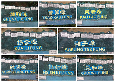
八仙嶺一共有八個山峰, 每個山峰都各自以道教八仙的名字而命名
Pat Sin Leng literally means "Peaks of 8 immortals". There are total 8 peaks in Pat Sin Leng, each peak has an individual name which named after 8 Chinese immortals.
天色開始變暗, 由早上晴天, 到後來多雲, 甚至大霧到什麼都看不見
The weather kept changing in the day. It was sunny in the morning but became cloudy and even foggy that we could hardly see.


No comments:
Post a Comment